About Grace

Grace Coelho Lehan "Gracie" to her friends was an avid amateur meteorologist. Mom bought me my first weather station when I was in Junior High School. It was a circa 1976 version of the SkilCraft Weather Forecaster kit with outside wind direction and speed. It had a liquid barometer to calculate pressure, a set of thermometers to calculate dry and wind-chill temps. The outside instruments included wind direction and speed and was mounted outside my window on the deck where the current Davis rain gauge is mounted now. She instilled my interest and dedication for forecasting and monitoring weather.
As a memorial tribute to her spirit and to keep her many friends & family apprized of the weather here in West Hartford Connecticut on the Rockledge after her passing in 2001, this weather station was activated on April 4th 2002, and has been in continual service since its dedication.
After many years of using the templates that originally came with Ambient Weathers Virtual Weather Station software, in 2005 I began modifying the template and gave the site a unique look albeit still simplistic. In 2016 trouble began brewing when Ambient Weather stopped releasing bug fixes and updates for VWS to account for site changes, security standard upgrades, and new technologies in weather forecasting and warnings. This combined with the softwares dependence on Weather Underground data, which began a contuining pattern of changing url's for access to referenced maps, charts and warnings, or simply just turning off products making them not available with no notice, caused many a VWS user to cry fowl. I spent many hours constantly searching for replacement products on other weather sites to replace the missing and defective Weather Underground products. This became a full time job in 2017.
In early 2018 I made a decision to upgrade the site using the Saratoga-Weather.com template package that many Personal Weather Stations around the world use to publish their data. The templates are attractive and flexible to accommodate personalization as well as being easy to implement. On April 4th 2018 Moms birthday, I began loading the new site and over a period of a month fleshed out the new site and began showing close friends such as Chris Moskey for input.
On June first 2018 I registered the URL Graceclehan.com and released this website to the world. In the near future I would like to add a webcam showing a view of the birdfeeders in my backyard as my Mother was an avid bird watcher, and over many years we have developed a following of many species of bird year-round.
About This Station
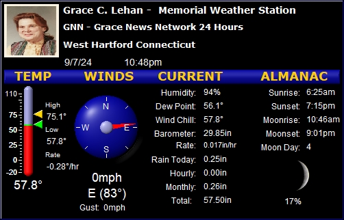
The station is powered by a Davis Vantage Pro 2 plus weather station. The data is collected every 5 seconds and the site is updated in real-time. This site and its data is collected using Virtural Weather Station v15 Software. The station is comprised of an anemometer, a rain gauge and a thermo-hydro sensor situated in optimal positions here on the Rockledge of West Hartford for highest accuracy possible.
A Dell Optiplex 960 running Windows currently acts as the weather station application server. It may be small but it does the job, 24 hours a day.
About West Hartford
West Hartford is an affluent suburb located in Hartford County, Connecticut, United States. Located 5 miles (8.0 km) west of downtown Hartford, the population was 63,268 at the 2010 census.
The town is known for its popular downtown area colloquially known as "West Hartford Center," or simply "The Center," which is centered on Farmington Avenue and South/North Main Street. West Hartford Center has been the community's main hub since the late 17th century. In 2008, Blue Back Square opened as a new addition to the central area. Blue Back includes a bookstore, a movie theater, two parking garages, various physician and medical offices, and several restaurants.
Incorporated as a town in 1854, the town was previously a parish of Hartford, founded in 1672. Among the southernmost of the communities encompassed within the Hartford-Springfield Knowledge Corridor metropolitan region, West Hartford is home to University of Hartford and the University of Saint Joseph.
According to new archaeological evidence, the Wampanoag people used West Hartford as one of their winter camps. Fishing and hunting along the Connecticut River, the area of West Hartford offered the Wampanoag people a refuge from the cold winter wind and the river's severe spring flooding. In 1636 Reverend Thomas Hooker led a group of followers from what is now Cambridge, Massachusetts to the "Great River" and eventually established the Hartford Colony. As the colony grew, additional land was needed. In 1672 the Proprietors of Hartford ordered that a Division be created to the West. A total of "72 Long Lots" were laid out between today's Quaker Lane in the East and Mountain Road in the West. The northern boundary was Bloomfield, and the Southern, present day New Britain Avenue. (The western boundary was extended in 1830 to include part of Farmington). In the 1670s the area was referred to as the "West Division" of Hartford. This remained the official name until 1806 when Connecticut General Assembly started referring to it as "the Society of West Hartford."
About This Website
This site is using a modified template design by CarterLake.org with PHP conversion by Saratoga-Weather.org.
Special thanks go to Kevin Reed at TNET Weather for his work on the original Carterlake templates, and his design for the common website PHP management.
Special thanks to Mike Challis of Long Beach WA for his wind-rose generator, Theme Switcher and CSS styling help with these templates.
Special thanks go to Ken True of Saratoga-Weather.org for the AJAX conditions display, dashboard and integration of the TNET Weather common PHP site design for this site.
Template is originally based on Designs by Haran.
This template is XHTML 1.0 compliant. Validate the XHTML and CSS of this page.